


Published on January 16, 2026 9:03 am
Last Updated on January 16, 2026 9:18 am
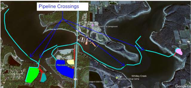

The U.S. Army Corps of Engineers, St. Louis District, is notifying the public of ongoing dredging operations at Lake Shelbyville that will include the installation of a floating dredge pipeline on the lake.
The dredge pipeline was originally planned to be submerged; however, due to current winter pool water levels, there is not enough water depth to safely allow watercraft to pass over a submerged line. As a result, the pipeline will remain floating for the duration of this phase of the project.
The floating pipeline will extend from the dredge to designated sediment placement areas. It will be supported by foam-filled floats and anchored in place to prevent movement. While pipeline crossings were initially planned, they will not be installed at this time because current water depths would provide only limited clearance over the pipeline. As lake levels rise closer to summer pool, pipeline crossings will be reevaluated, and the public will be notified of any changes. For public awareness and safe navigation, the pipeline will be clearly marked along its entire length. White buoys labeled “Danger Dredge Pipeline” will be installed approximately every 30 feet and equipped with amber, solar-powered flashing lights visible up to two miles at night under clear conditions. Red buoys with red, solar-powered lights will be placed at the ends of designated channel crossing areas. Where feasible, the pipeline will be positioned near the shoreline and secured to reduce interference with recreational use of the lake.
In addition to pipeline markings, the dredge itself will be clearly identified to enhance navigation safety. The dredge will display appropriate warning signage and lighting to indicate that it is restricted in its ability to maneuver. All-around white lights will be visible at night to help recreational boaters identify the dredge’s location and avoid the work area.
The floating pipeline and associated dredging activities are expected to remain in place for the duration of the dredging project. The U.S. Army Corps of Engineers will continue to monitor lake levels and project conditions and will provide updates as conditions change.
Boaters and other lake users are reminded to maintain a safe distance from dredging equipment, obey all marked navigation warnings, and use caution when operating watercraft near the project area. A map showing the approximate location of the dredge pipeline and buoy markings is included to help the public better understand where the pipeline will be located and how to safely navigate around the project area.
For additional information and updates, please visit the Lake Shelbyville, U.S. Army Corps of Engineers Facebook page or call 217-774-3951.
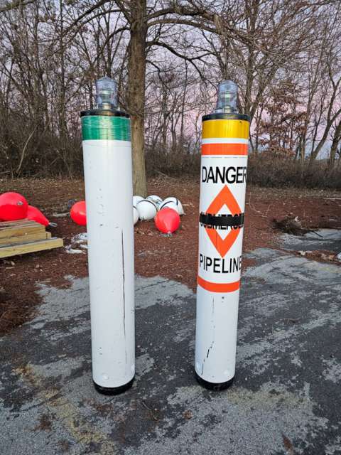
Examples of buoy and lighting used to mark the dredge pipeline.